Aug 292018
 

1940s Corps of Engineers booklet: “Table Rock Reservoir Area, White River Missouri and Arkansas, and how the U.S. buys it.”

Two boys cast fishing lines from their perch on the rocky slope of the “bath tub ring” caused by fluctuating water levels of artificial impoundments. They wait for a nibble watching the flat water of Table Rock Reservoir, perhaps wondering where the fish are hiding and what lies beneath the stilled waters of the lake that covers the once mighty White River.

Folks living in the White River and James River valleys had had fifty years to come to terms with the inevitability of losing working farms, grist mills, tiny towns and sylvan groves to rising waters when the dam closed. Still, this booklet by the Corps of Engineers seems particularly insensitive to the losses rural people faced as they gave up their land and lifestyles to the massive project. They do acknowledge that “the long-established procedures (for buying land in the project area) are not well understood by many in the reservoir area where land must be obtained in order to obtain storage to impound and control flood waters . . . ”

Tom Koob’s book, Buried by Table Rock, paints a picture of the life once lived in the valleys of the White and James rivers.

James Fork of the White and other Lens & Pen books are available on this website, on amazon.com and at Barnes & Noble.

Jul 182018
 

Our new project, Lover’s Leap Legends: From Sappho of Lesbos to Wah-Wah-Te of Waco, may not seem on the surface to be a logical offshoot of past projects—but in fact it is. Inspiration from our hero, Mark Twain, and finding in each of our river books their own #Lover’sLeap legends and locations pulled us logically to this new subject.

Real photo postcard by George Hall circa 1915. Virgin Bluff was a landmark on the Galena to Branson float. While tame compared to the shoals of the upper reaches of some Ozark rivers, the rapids just before the big bluff were sporty for the James.

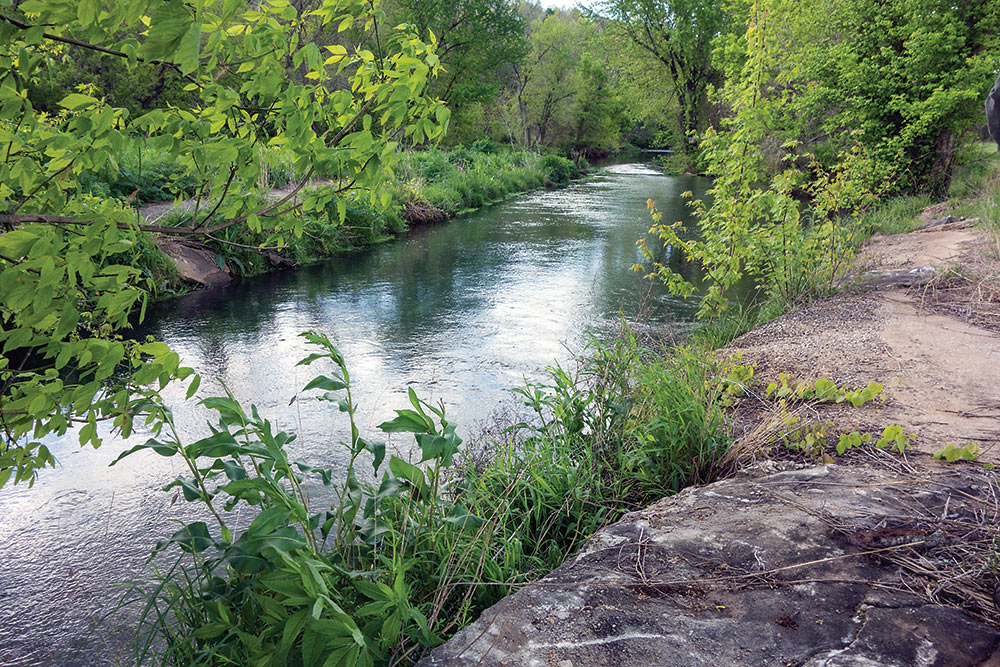
Research on the James Fork of the White brought us to #VirginBluff, a spectacular, sheer rock face on the James, that was a landmark on the Galena-to-Branson float. Johnboats floated through a long, deep, fish-filled pool along its face, then the current pulled the boats into the sporty Virgin Shoals.

This bluff came with its own Lover’s Leap legend – or so we were told. Moon Song, the lovely daughter of an Indian chief, threw herself from this imposing cliff when her father threatened to kill the handsome, gold-seeking Spanish soldier she loved. Angry and heartbroken, her father ordered the medicine man to place a curse on the tragic place. Moon Song’s anguished cries can yet be heard on dark nights, some say. Before the lake the shoals below claimed the lives of several floaters.

The Virgin Bluff dam-that-never-was may have been victim to the medicine man’s curse. William Henry Standish envisioned a dam on the river and a tunnel through the hills from the bluff to shoot the pooled water on a 40-foot drop over several miles to hit turbines to spin generators to create electricity for Springfield. This crazy scheme would have dried up 30+ miles of the river.

A November 23, 1958 Springfield News-Leader feature, “The Indian Curse That Killed Dam Project,” by Gerald H. Pipes, is a rare remembrance of Standish’s plan. Pipes did acknowledge the adverse financial climate of the times (just before World War I), but speculated the abandonment of Virgin Bluff dam might have been due to workplace accidents related to the Indian legend:

Today the lonely “cries” of Moon Song may still be heard along the bluffs, but the dangerous shoals will soon be gone, for they will become a part of mammoth Table Rock Lake. The waters will climb over and hide the Indian maiden’s grave and the scars left by the dam-builders. But will they erase the curse placed on the bluff by Moon-Song’s chieftain father? Only time will tell.

James Fork of the White, page 275

Today, the bluff rises above the flat waters of #TableRock Reservoir. A fall from this bluff is still dangerous; the view from its heights has changed considerably. The legend lingers in the name, Virgin Bluff, and a small winery on the bluff once produced several varieties including Moon Song Blush, Virgin Bluff Red, and Virgin Bluff White.

James Fork of the White and all our books are available on this website, on amazon.com and at Barnes & Noble.

Jul 112018
 

Owen and his band of guides, raconteurs and artist Steve Miller hang out in front of Owen’s Hillbilly Theater in downtown Branson.

Owen’s roster included many who had pioneered floating the James and White back in the days when city folks detrained at Galena. Few guides worked full time. Some continued to offer their services to Galena operators. The Branson businessman’s aggressive advertising reeled in the most clients and in the twenty-six years he packaged trips he would use almost every river man at one time or another. Jim Owen became an institution, but some of his guides had reputations for their fishing acumen, campfire cooking skills, or country wit. A jokester himself, Owen encouraged colorful rustic behavior that fulfilled visitors’ expectations of being escorted downstream by a tractable variety of hillbilly.

James Fork of the White (p. 235)

James Fork of the White is available on this website, on amazon.com and at Barnes & Noble.

Jul 022018
 

Most often reviews of books are done when the book is first published. So this review of Buried by Table Rock: Tales, anecdotes and facts about everything covered by the lake is late in coming, although Koob has recently published a revised edition. However, we discovered this small volume as we researched James Fork of the White, and it has been more than useful. It is a modestly published book, but an invaluable resource.

Tom Koob dug into newspapers, government records and—most importantly—he talked with the people, drove the roads, climbed the remaining hills, found the remnants of summer camps along the river. He gathered rare images to illustrate both past and present reality. He scanned the flat waters covering a once-peopled landscape and searched out the families and towns that once occupied it. River guides, mill families, and farmers recalled life with a river that gave them recreation, transportation, danger and sustenance. Nostalgic memories are tinged with regret at the loss of their river.

He identifies the visible remnants of places he describes in the text:

“Two small islands can be seen to the north from the Long Creek Bridge. The larger island is the top of Goat Hill, the site of the small town of Oasis. The smaller island, where a handful of trees cling tenaciously, is the peak of the slope that rose behind the town.”

Our own environments have become more homogeneous. We have Homeowners Association suburbs with architectural and landscaping covenants; uniformity of fashion in national chain department store shopping centers; even local government policies aspiring to emulate those of major urban centers—sameness creeps over daily life and we hardly notice. But the lives and landscape Koob describes are regionally specific and adapted to Ozarks geography. As he said so clearly:

I have come to realize though, that the real story is something else. It is the story of a rugged land and rugged people. It is a tale of a somewhat isolated culture thrust into a modern world not necessarily of its own choosing.

The final pages have photos of the rising waters covering landmarks in the White River basin—Stallions Bluff, the Bridge at Mash Hollow at Cape Fair, and the James River Bridge at Cape Fair.

Those who read Tom Koob’s book will never look at Table Rock Reservoir the same way again.

You can find Tom Koob on Facebook  His newest book is a historical novel, Virgin Bluff. He has just published a revised edition of Buried by Table Rock. His books (The History of Fishing Table Rock; Buried by Table Rock; and Enon to Radium Springs) are available on Amazon Kindle

Jun 092018
 

Floating was never an exclusively male sport. Fishing may have been the justification for a five-day, four-night float on the James River, but the evening campfire was its own sensual experience – a time for the universal pleasures of freshly caught fried fish, tall tales, and leisurely conversations.

James Fork of the White is available on this website, on amazon.com and at Barnes & Noble.

Mar 132018
 

A year ago – almost to the day – Ken White published an article on the opening of the 2017 paddlefish season on the Osage River and its tributaries. A couple of days ago, we found an almost identical article in a couple of regional newspapers, including the Springfield News-Leader. Last year, we wrote to Mr. White, noting the absence of any reference to the artificial breeding program for paddlefish at Blind Pony hatchery run by the Department of Conservation. Made necessary by the destruction of this ancient fish’s primary spawning beds when Truman Dam closed, the fish now trapped in lakes or swimming the upper or lower reaches of the Osage are hatchery spawn, and paddlefish snagging season is an outgrowth of the put-and-take program, fundamentally no different than hatchery trout with the same potential for disastrous genetic outcome.

Repeatedly, Mr. White refers to their “spawning run . ..  when the fish are concentrated in their spawning grounds.” Then he speaks of their “spawning rituals.”  Mr. White, please verify with an ichthyologist or limnologist that they are in fact successfully spawning in Missouri rivers. And he ends the piece with snaggers “ready to hook a fish that has survived for centuries.” As the paddlefish no longer successfully reproduces, they will “survive for centuries” only if the expensive artifical spawning program of the Conservation Department survives future budget cuts and the genetics don’t degenerate with reproducing a limited gene pool.

Right: Paddlefish legally snagged on the James River arm of Table Rock Lake near Cape Fair. 

“Paddlefish have been lost from four states and Canada, and eleven of twenty two states within the remaining species range now list the paddlefish as endangered, threatened, or a species of special concern. Restoration of paddlefish populations is a shared goal of many state and federal agencies.” (USGS)

Below: Map from USGS paddlefish study showing the diminishing range of the paddlefish


If journalists like Mr. White continue to ignore the scientific realities of conservation of species, how will the public be able to make informed choices when such issues are presented in the public forum? Truman Dam is the source of the paddlefish’s dilemma. Had the public realized the consequences of this monstrously unwise project, the lawsuit might have had a different outcome. At the time, the Conservation Department repressed the findings of their fisheries biologists because one of the commissioners was an avid supporter of the project. Ignorance continues, abetted by Mr. White.

Last year, we even offered to send him a copy of our book, Damming the Osage. Mr. White did not reply. So this year, we won’t email him our suggestions. We’ll just share our thoughts with you.

March 11, 2017:
Your article was informative about the paddlefish and included some local color and good pictures. However, there was no mention of the sad fact that snagging is a put and take fishery. The “spawning run” is a swim up the river to futility. Paddlefish snagged in the Osage above Bagnell Dam and James River arm of Table Rock are artificially reproduced and raised at the Missouri Department of Conservation’s Blind Pony Hatchery. This is a hugely expensive operation and will, in the long run, produce a genetically unfit creature that resembles the malformed rainbow trout that are the product of generations of aquaculture. Department biologists are well aware of this and it can be overcome somewhat by mixing in genetic material from paddlefish from other regions but that’s a lot of trouble and adds even more expense.
Truman Dam destroyed the only reliable paddlefish spawning environment. Occasionally eggs are produced on the upper Osage and James but there’s no indication they survive and mature.  It’s a very bad situation and if the public doesn’t understand it, the extraordinary measures that may be necessary in the future for the survival of the species may not be undertaken, as funds are research will surely be necessary.
We cover this in a book we published several years ago, Damming the Osage. If you’d like a copy, please email me your mailing address. We have quite a discussion of these issues on our website: www.dammingtheosage.com
It’s a nice piece, but incomplete. Sooner or later there will be more challenges for the paddlefish and only a community of well-informed sportsmen stand between survival and extinction. Truth is they are hanging from a slender thread even with the heroic actions of the Department of Conservation.

Our sons, Strader and Ross, supplied some video of paddlefish in China which we incorporated into a short video on the current dilemma of the paddlefish worldwide. See it on YouTube: https://youtu.be/rmT090b9NT0

Damming the Osage and James Fork of the White are available on this website, on amazon.com and at Barnes & Noble.
Jan 232018
 

Since mid-December, the Springfield News Leader has followed the discovery and monitoring of a recently opened up “swallow hole” on the James River, near the Greenway Trail in southwest Springfield.

A dramatic sucking sound accompanies the whirling vortex as hundreds of gallons of the stream’s water disappears down the dark hole. It’s a graphic auditory and visual illustration of the porous nature of the karst typography we live on.

Loring Bullard, author of Jordan Creek: Story of an Urban Stream and past president of the Watershed Committee of the Ozarks, was one of those who found the swallow hole. He described the whirlpool as “a crack in the creek bed . . . sucking hundreds of gallons of water into a subterranean channel that likely exited more than a mile downstream at Rader Spring.”

Our research for James Fork of the White led us to Rader Spring as well. An unspectacular outpouring in a field near Wilson Creek, the spring did not historically attract the leisure class for picnics and dalliances. Still, it is instructive of our landscape. Of Rader Spring, we wrote:

The spring only a hydrologist could love pumps around six or eight million gallons a day into the now-cleaned-up Wilson Creek – a third as much as Missouri’s twentieth biggest spring. Still, it’s a lot of water, but size is not what endears it to geologists. The Association of Missouri Geologists took a field trip here and Kenneth C. Thompson wrote, “Perhaps the most unusual characteristic of Rader Spring and its supply system are the reversible sinkholes or estavellas that occur in the Wilson Creek valley. These curious karst features accept water in drier seasons and discharge water as springs during rainy seasons.” (p. 53)

The mysterious movement of water under the surface of our earth has been studied and pondered by generations of geologists, hydrologists, landowners as well as recreationalists who observe the outcomes of that movement. Dry creeks and sinking streams, which have intermittent water supplies, also prove that, although we may not see it, water courses through a complex subsurface system that does not necessarily copy the channels we see from a low water bridge. Pouring dye into one water source and waiting to see where it resurfaces is the most common method of tracking that movement.

Rader Spring is a textbook example of how leaky the Springfield Plateau is. Fluorescent dye introduced into creeks and sinks from as far away as I-44 have been detected in Rader’s waters. From a dry branch of Nichols Creek six miles away dye was injected that reached the spring in six days. Rader is only 1.3 miles from Springfield’s Southwest Waste Water Treatment Plant. (p. 53)

Fluorescent dyes have been introduced into some dry streambeds and sinkholes along Flat Creek a few miles from Cassville and emerged in the great spring at Roaring River. That twenty-six-million gallon-a-day frigid water source for a state trout park is not in the James River basin. Subsurface water movement does not always follow present-day surface stream configurations. (p. 94)

James Fork of the White: Transformation of an Ozark River is available on this website, on amazon.com and at Barnes & Noble.

Jan 212018
 

If you turn west from Highway 13 on Joe Bald Road, you’ll pass the entrance to Joseph Philibert Cemetery. Named for the first white settler in Stone County, this hilltop cemetery is where the graves of twenty small graveyards in the Table Rock Lake basin were relocated.

Among the markers are those for William Carol “Tipton” Gore and his second wife, Nancy “Granny” Gore, “Cherokee Doctor.” Nancy Gore was born in Tennessee about 1820, married William Gore and they moved to Arkansas, then to Stone County about 1848. They settled near the confluence of the James and White rivers. Their neighbors were the Joseph Philibert (1812-1884) and William Gillis families who had a trading post where they bought furs from the Indians. The Philibert family graveyard was near the site of the trading post. Twenty-two graves were in the old cemetery when Table Rock Lake began to fill. Among those were the Gores.

Headstones were modest, and many burials were only marked with rocks to indicate a grave. A new marker was made for Granny Gore, a Cherokee medicine woman and wife of pioneer William Tipton Gore. Small family cemeteries in the basin of Table Rock Reservoir were moved to higher ground before the lake filled. Headstones and remains of twenty graveyards, such as they were, were dug up and relocated in the new Joseph Philibert Cemetery just north of Kimberling City.
                                                                  James Fork of the White: Transformation of an Ozark River

Granny Gore’s Ozark Folk Medicine by Sherman Lee Pompey:

And finally in the words of Granny herself, “You see, the good Lord made herbs an’ roots for the purpose of medicines. A lot of medicines that we used in the early hills was nothing more than the same thing or the artificial substitute of these things used today by modern medical science.”

Dec 052017
 

For an author, it’s deeply gratifying when a reader really understands what you’re doing and why. Steve Wiegenstein’s review of JAMES FORK OF THE WHITE: Transformation of an Ozarks River is that kind of review. Steve understands the subject and our own non-linear style of treating our topics.  Most importantly, he understand the Ozarks, the land, the streams, the people. Steve is the author of a series of historical novels set in a mid-nineteenth century Utopian community named Daybreak in a valley of the St. Francis River in Madison County.  The third in this series, just-published The Language of Trees, has earned high praise.

James Fork of the White is available on our website, www.beautifulozarks.com, at Barnes & Noble and on amazon.com

Dec 032017
 

Last week Steve Pokin, the Springfield News Leader‘s columnist of the unique and sometimes quirky aspects of Springfield, interviewed Leland about our new book, JAMES FORK OF THE WHITE: Transformation of an Ozark River.

In his columns, “Pokin Around” and “Answer Man,” Steve answers readers’ curious queries, investigates puzzles and reveals many of Springfield’s little known facts and interesting personalities. One of In his columns on the (eutrophic) small lakes of Southern Hills subdivision provided needed background information for us as we discussed Galloway Creek and other small tributaries flowing into the James.

We’re gratified that he concluded, “Interested in the James River? This is the book for you.

Available from our website, www.beautifulozarks.com (postage paid), Barnes & Noble and at amazon.com.